I have mentioned before that Don does not like roads that hug sheer cliffs so our trip to Yosemite was a real voyage. As I have also mentioned he does not like handing over the wheel to me because it makes no difference who is driving when we are at the cliff's edge. Ergo, when we hit the long slow climb that is the road up to Yosemite National Park it was not a happy surprise.
 |
| This is actually on the way to Yosemite Valley from the campground which is west of it. There is also a small wall. Picture this road with no wall and 100-180 degree turns |
The first part of the journey had been uneventful-we drove along I-5 until we got onto Rte 99 and then 120. 120 winds and twists through farmland and open spaces until it starts to climb. There is a bit of a respite at Groveland where the road levels out a bit and you are driving between buildings but then the ascent begins to get serious and at Buck Meadows the signs about "sharp curves for the next X (usually 5 or 6) miles" begin and the speed, already slow because the road is literally cut from the side of the mountain, decreases further. I was fortunately seated on the cliffside of the vehicle and was enjoying peering down the steep slopes but then again, I was not piloting 22,000#/1000 Kg vehicle towing a 3500#/1600 Kg car up and around the corners that were very sharp. But, happily we made it with no mishaps of any type and pulled into Crane Flat Campground with plenty of daylight to set up. THAT was a good thing because the site we'd reserved (for a 35'/10m motorhome) not only did not fit us but was hopelessly unlevel. You see there was a 2 foot/60 cm deep rut right in the center. No matter which way I maneuvered the RV, I could not avoid the rut. No matter how I parked ALL of our leveling blocks could not lift our front end to anything close to level. So, I went to the gate to ask if there was anything else available and after much discussion they decided we could switch to a site that was "held in reserve" for problems. It turned out to be on the other side of the area where our first site was and though it too was not anywhere close to level there was no rut to be avoided. After 2 hours of backing up, riding onto blocks, backing up, swinging around a bit and going back onto blocks we gave up. We were level side to side but for the 4 days we were there we had to walk uphill from the front to the back of the MoHo. This whole procedure had taken up the rest of the daylight so we sat back and decided to plan the next days' activities. That's when we realized we had not stopped to get water and there was "none" at Crane Flat. Then we noticed that the spigot outside the bathrooms, which were right next to us would be perfect, and with our "Water Bandit" (it is a sleeve that slips on to threadless faucets) Don filled the tank with fresh water. Then we started to plan for the next days again.There are several areas to see in Yosemite and none are close to the others.


The next day, our first, would of course be spent at Yosemite Valley where most of the well known sites are located: Half Dome, El Capitan and Yosemite Falls to name 3. The drive there required a little more mountain hugging and at one point our phones, which were silent in the dead zone of the campground, started dinging with incoming messages and mail-for about 100 ft and the silence again until the Visitor Center. Phoenix was with us but would not be allowed in the buildings so we nabbed a very shady spot with a bit of a breeze, set up her window nets and filled her water bowl. She settled in to sleep before we had even left the parking lot. We toured the Visitor Center, bought stamps at the post office, ate a quick lunch, while conversing with a family from UT, and walked around the Village before going back to the car to drive around and see the sites. Yosemite is one of the popular parks and there was traffic everywhere we went. Parking lots were full and roadsides crowded with people trying to get to trailheads. We drove on but only stopped briefly at a few stops, resolving to visit less crowded areas in the next days.


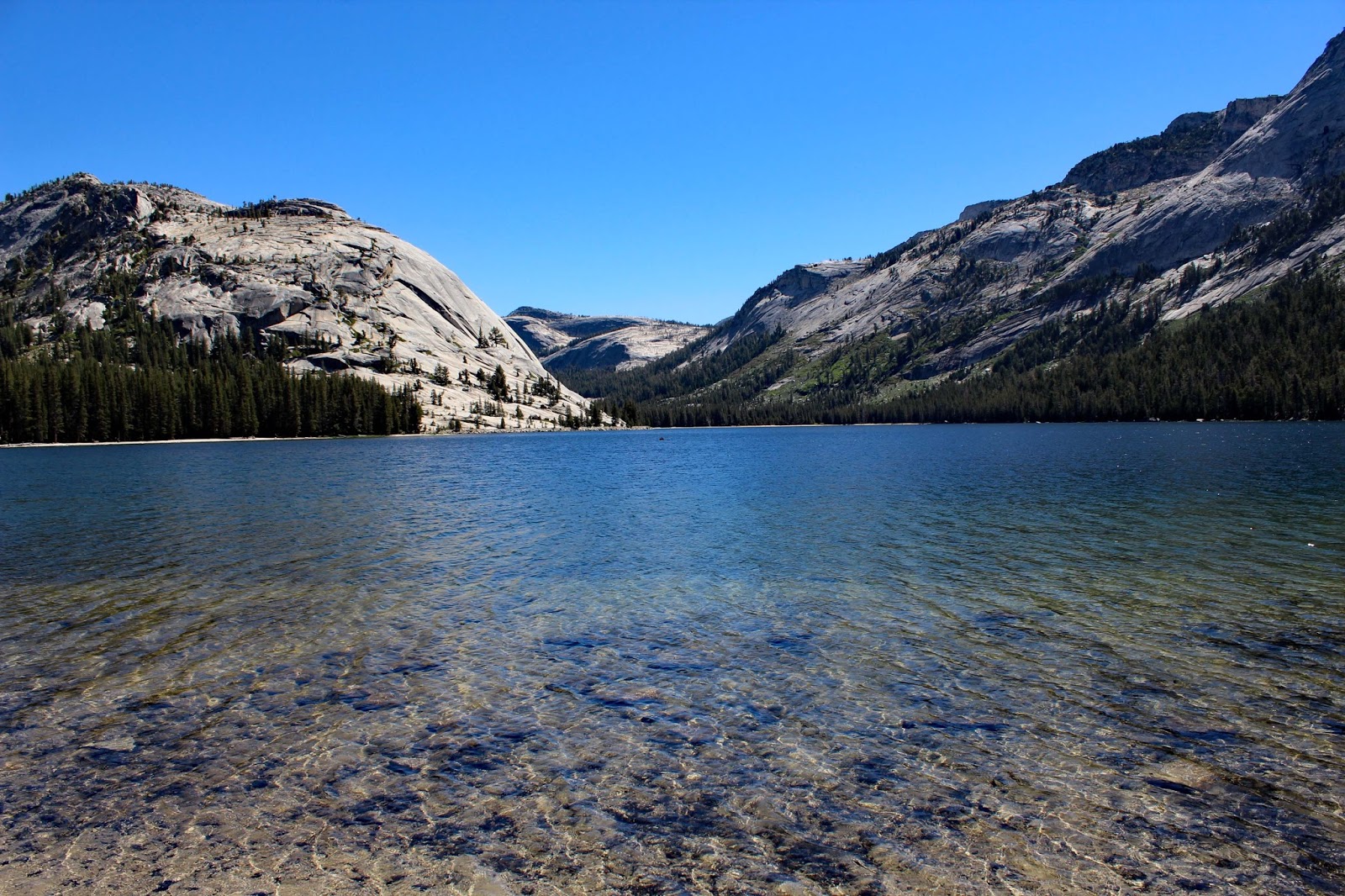
To that end, the next day we drove up the Tioga (pronounced tie O gah) Road to Tuolumne (pronounced TWAH-lum-ee) Meadows. A detour into White Wolf campground yielded us a brief glimpse of a young brown bear scooting across the road and as it turned out, our only bear sighting. We stopped briefly again to walk down to small lake and then continued to our first viewing stop-Olmsted Point. From there the view of the backside of Half Dome is spectacular. There is a short hike down and around some boulders that yields nice views as well of Tenaya Lake, Tenaya Peak and Mount Conness. The day was yet another beautiful sunny one with a slight coolness due to the elevation and the hike was lovely. Getting back in the car we drove down until we arrived at Tenaya Lake with its sparkling blue waters surrounded by soaring peaks and hills. From there it was more beautiful scenery until we came into Tuolumne Meadows and stopped for lunch. The crowds were not only far sparser but of a completely different type. There were tens of young people who were hiking through the park. Tanned, muscular and young they would unload backpacks as big as small cars from their backs as if they weighed nothing and then sit in the sun laughing and joking with each other. Friendships formed on the trail and at this spot would lead to joining or leaving groups to continue their journey. We sat next to a family from China at the picnic bench we shared and had a great time explaining to the kids, through their parents who spoke a smattering of English, what their hot dogs and other items were. One of the kids could not get enough of the new foods, while another wanted nothing to do with each after the first bite.


 |
| If you look carefully there is a thin line about one third of the way across Half Dome, from the left. It is a line of hikers going up to the summit. |
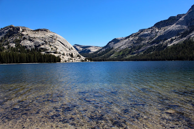 |
| Tenaya Lake, named after Chief Tenaya who met the Mariposa Brigade at its shores. It was formerly known as Pieweack (Lake of Shining Rocks) |
We drove onward and upward from the meadows only a little while further to Tioga Pass where we turned around to head home. Having spent a long while talking with a couple from Paris the night before we came back that day to meet 4 families from Argentina who were caravaning to several national parks and who were in the midst of barbecuing several large steaks. The scent was tempting and their invitation for us to join them more so but we were both so beat and feeling the elevation that we begged off-with huge regrets.
We spent the morning finishing chores and getting ready to leave the next day as we were heading out later rather than earlier. I don't like visiting places-especially the photogenic ones when the sun is high overhead and the light harsh. I wanted to see and photograph Glacier Point and the views from there with the sun lower in the sky but Don wanted to ride when there was a bit of light so we compromised and went mid afternoon. We agreed to meet in 3 hours but little id I know what the traffic would be like and when I got to Washburn Point, the stop before Glacier, I literally ran over grabbed a few pictures and headed to Glacier. Of course, I had gotten a message when the signal came in range that my mother had called and I was worried something as wrong so called her. Everything was OK and we chatted for awhile before I realized I need to get a move on. Glacier Point is not a place you simply park your car and get out, stroll over to a viewing point but one where there are two levels in the parking area, and a rather long walk out to the point. Worth it? Oh yeah. The light was OK and I kept wishing I could stay later but I was now facing the fact that I would not make it to our rendezvous point in time and there was no way to let Don know. I grabbed a few pictures took a moment to take in the scenery and the beauty and then drove back down as fast as I was allowed. Don had been cycling back and forth between two points thinking I might have missed the spot (and he was right) but we caught up to each other and all was well.

 |
| On the way I stopped at for a valley scene, |
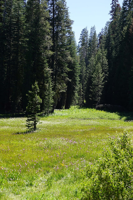 |
| and a meadow, |
 |
| and then at Washburn Point |
 |
| Half Dome |
When I arrived at the Glacier Point parking lot I was
on the phone with my mom and this little guy
was putting on quite the show for me right in front of the car.
As I ran to the lot to get back to the car this pheasant was perched on a boulder.
It was only as I ran past it that I saw her chick in the bushes below.
We left Yosemite glad we'd seen it, and not knowing whether it was not having enough time to really enjoy it-do some more hikes, stop and spend time in places or whether the drought has taken its toll on this great valley and removed some of the lushness that seemed to be lacking. But, we were glad we had been able to visit and once again noted how many foreign visitors there were.
As we left Don told me he wanted me to drive back down, I happily accepted and so I got to pilot us down the winding road until we were once again on flat land where he took over again and I got to gaze at the scenery on the way back to the farm in Isleton.


No comments:
Post a Comment
Hello!
Anyone can comment. You do not have to sign in, just post your comment and it will come to me for moderation. That's just so I can weed out the extraneous Anonymous who is up to no good :-)
I'd love to hear from you about what you think and if you have any questions, especially about the places we've been, living in an RV or living on the road.